

本文由 24 ScanLAB 授权mooool发表,欢迎转发,禁止以mooool编辑版本转载。
Thanks 24 ScanLAB for authorizing the publication of the project on mooool, Text description provided by 24 ScanLAB.
24 ScanLAB: 本项目是2022 深港城市\建筑双城双年展(UABB)深圳粤海城参展作品
24 ScanLAB: This project is a participating work in the 2022 Bi-City Biennale of Urbanism\Architecture (UABB) in the Shenzhen Yuehai City.
三维激光扫描 X 计算机视觉X 机器狗,呈现数字孪生视角下的城市人群活动轨迹
3D Laser Scanning X Computer Vision X Robot Dog, Presenting the trajectory of urban people’s activities from the digital twin perspective
▽影像预告片,Trailer ©24 ScanLab
本团队对深圳这座具有代表性的”密度-活力”城市进行了深入的记录和调研,将看得见的”建筑/城市空间模型”与看不见的”人群活力地图”相结合,从城市叙事视角来研究居民的日常生活。
我们在展区中以视频作为载体,运用三维激光扫描技术展示数字化的建筑和街道景象。同时还运用机器学习技术和机器狗,从周期性监控视频中提取出人群的活动轨迹,叠加在场景之上,让观众能够感受到现实空间与人群活动的动态交叠,展现出难以察觉的空间活力与密度。
我们希望能够通过这个展览,为城市居民更好地了解城市的运作机制,为日常生活带来更多的便利和舒适,为未来城市规划和管理提供有价值的建议。
Our team conducted an in-depth record and research on Shenzhen, a representative “density-vitality” city. We combined the visible “architectural/urban space model” with the invisible “crowd vitality map” and studied the daily lives of residents from the perspective of urban narrative.
In our exhibition area, we use video as a carrier and 3D laser scanning technology to display digital architecture and street scenes. At the same time, we also use machine learning technology to extract the activity trajectories of the crowd from periodic monitoring videos and superimpose them on these scenes, allowing the audience to feel the dynamic overlap of real space and crowd activities, presenting the difficult-to-perceive spatial vitality and density, and presenting the “new mode” direction of the development of urban villages in the city.
We hope that through this exhibition, we can bring meaningful discoveries and insights to everyone, better understand the operation mechanism of the city, bring more convenience and comfort to the daily lives of urban residents, and provide valuable suggestions for future urban planning and management.
▽影像概览,Film Overview
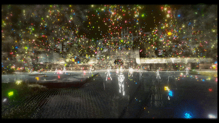
▽南头古城城门广场全景扫描,3D Scan of Nantou Ancient Gate Square

▽城门广场活力轨迹,Gate Square Vitality Track

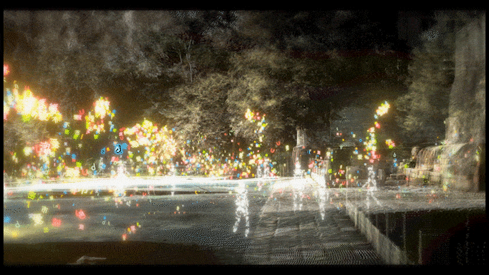
▽东莞会馆全景扫描,3D Scan of Dongguan Guild Hall
三维激光扫描 3D Laser Scanning
三维激光扫描(LiDAR)作为一种成熟可靠的大空间测量技术,可以快速采集真实环境并转为数字化模型资产,被广泛应用于古建筑测绘、文化遗产保护、地质勘探、工业工程、汽车自动驾驶等工程领域。随着数字孪生和元宇宙话题的兴起,也让这项面对专业层面的技术被应用到消费者层面,如 VR、AR、三维打印、影视娱乐、线上博物馆等,并不断探索更多拓展应用的可能。
Three-dimensional laser scanning (LiDAR) is a mature and reliable large-space measurement technology that can quickly collect real-world environments and convert them into digital model assets. It is widely used in engineering fields such as surveying and mapping of ancient buildings, protection of cultural heritage, geological exploration, industrial engineering, and autonomous vehicles. With the rise of digital twins and metaverse topics, this technology has also been applied to the consumer level, such as VR, AR, 3D printing, entertainment, online museums, and is constantly exploring more possibilities for expanded applications.
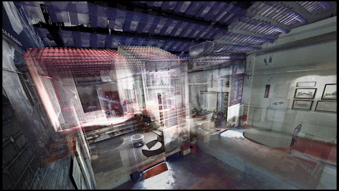
▽实时点云建图,Real-time point cloud building

计算机视觉 Computer Vision
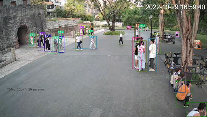
在本项目中,我们使用计算机图像识别技术从视频中提取人群的特征轨迹,并统计出不同时段下的密度分布,绘制出城市中难以觉察的“人群活力地图”。 这种方法不仅可以帮助我们更好地了解城市的人群流动情况,还可以为城市规划提供有价值的信息,更好地优化城市的运营和管理。
此外,我们还希望通过这个展览,让大家了解到计算机图像识别技术和机器学习技术在城市研究中所扮演的重要角色。我们希望能够展示出这些技术在城市研究中的应用方法,并向大家介绍这些技术的基本原理。
In this project, we use computer image recognition technology to extract the characteristic trajectories of the crowd from the video and statistically calculate the density distribution at different times to draw the “crowd vitality map” that is difficult to perceive in the city. This method can not only help us better understand the crowd flow in the city, but also provide valuable information for city planning to optimize the operation and management of the city.
In addition, we also hope that through this exhibition, people can understand the important role that computer image recognition technology and machine learning technology play in urban research. We hope to show the application of these technologies in urban research and introduce the basic principles of these technologies to everyone.
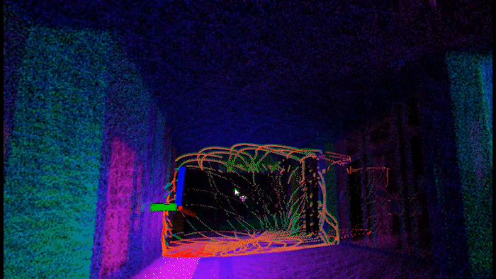
▽人物轨迹识别,Character trajectory recognition

机器狗 Robot Dog
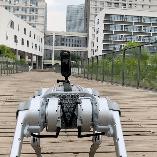
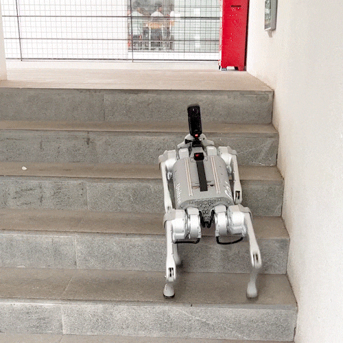
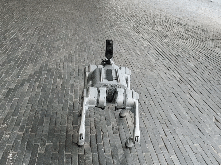
机器狗是一种四足机器人,相比于履带式机器人具有适应复杂环境、上下楼梯、避让行人的能力。通过安装扩展套件,机器狗可以执行多种复杂任务。在本项目中,我们利用机器狗的远程操控和长续航特性,协助工作人员完成周期性巡逻任务,在多个时段采集场地视频信息和三维扫描点云,大大降低了传统方法的体力劳动强度。我们还在进一步提升对四足机器人步态的理解,挖掘机器狗的实际应用潜力。
Quadrupedal robots, also known as “Robot Dog”, have the ability to adapt to complex environments, climb stairs, and avoid pedestrians. By installing expansion kits, these robots can perform a wide range of complex tasks. In this project, we utilized the remote control and long endurance capabilities of a quadruped robot to assist workers in completing periodic patrol tasks, collecting video information and 3D scanning point clouds at multiple times, significantly reducing the physical workload compared to traditional methods. We are also furthering our understanding of legged locomotion and exploring the practical application potential of quadrupedal robots.
▽机器狗辅助信息采集,Robot dog assisted information collection ©24 ScanLab

▽幕后制作视频,Behind the Scene ©24 ScanLab
▽展览现场,Exhibition Venue


项目名称:深圳城市密度与活力的数字化感知与呈现
项目类型:展览空间,视频设计
出品机构:深圳大学,24ScanLAB激光扫描实验室
公司网站:www.twotenfour.com
联系邮箱:hi@twotenfour.com
公众号:24ScanLab
完成年份:2022
主创设计:范悦,王浩锋,艾登,张星
团队成员:彭然然,杨冰杰,黄宁秀,林毅苗,何雨聪,黄展鹏
项目地址:深圳粤海城·金啤坊
Project Name: Digital Perception and Presentation of Density and Vibrancy in Shenzhen
Project Type: Exhibition Space, Video Design
Producing Institution: Shenzhen University, 24 ScanLAB
Company Website: www.twotenfour.com
Contact Email: hi@twotenfour.com
Public Account: 24ScanLab
Year Completed: 2022
Lead Designer: Fan Yue, Wang Haofeng, Aiden, Zhang Xing
Team Members: Peng Ranran, Yang Bingjie, Huang Ningxiu, Lin Yimiao, He Yucong, Huang Zhanpeng
Project Address: Yuehai City, Shenzhen
“ 用数字化设计,为人们的日常生活带来更多的便利和舒适。”
审稿编辑:Maggie
更多 Read more about:24ScanLAB


0 Comments