

本文由Burgos & Garrido Arquitectos授权mooool发表,欢迎转发,禁止以mooool编辑版本转载。
Thanks Burgos & Garrido Arquitectos for authorizing the publication of the project on mooool, Text description provided by Burgos & Garrido Arquitectos.
Burgos & Garrido Arquitectos:2003年,马德里市议会决定填埋该市第一环路(M30)以西10公里的路段,这一路段沿着曼萨纳雷斯河的两岸延伸。 M30最初的建设不是单一设计的结果,而是在过去40年里根据交通发展需求慢慢形成的,在这些后果和副作用中,它抹去了城市与河流的联系,使城市变得黯淡、难以接近。
Burgos & Garrido Arquitectos:In 2003 Madrid City Council decided to bury the 10km western stretch of the city’s first Ring Road, known as the M30. This West section travels along both banks of the Manzanares River. The original construction of the M30 was not the result of a single design, it had taken place carelessly during the last 40 years and its development had always been dependent on traffic demands. Amongst the consequences and side effects, it erased the city’s connection to its river, rendering it inaccessible and invisible.
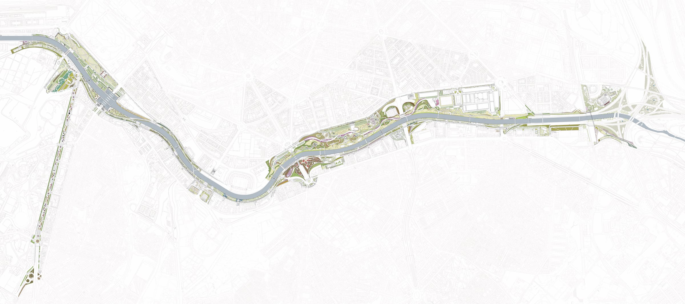
▼总平面图 Master plan

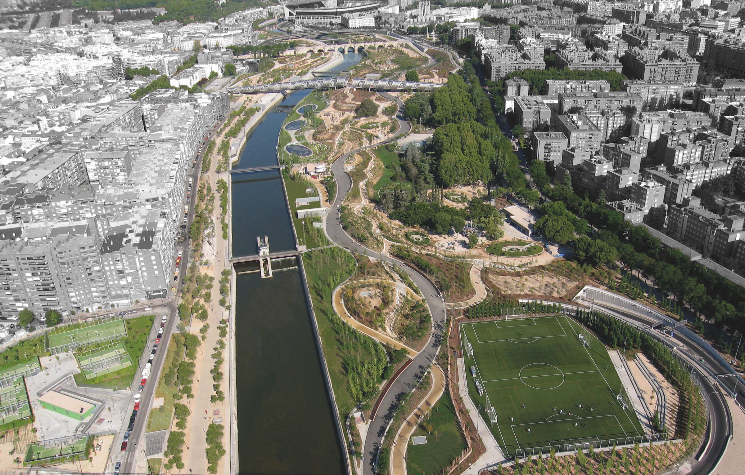
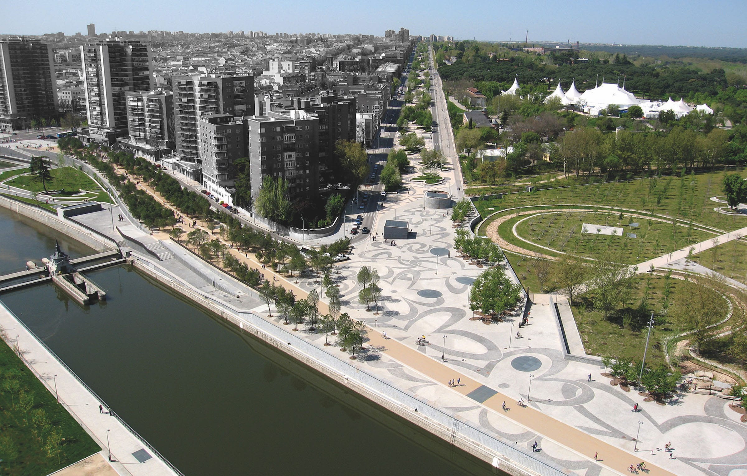
高速公路被掩埋后,在马德里市中心,距离皇宫及其花园不到半英里的位置形成了一个巨大的公共开放空间。河道的总长度超过40公里,每天有20多万辆汽车通过,其建设涉及掩埋输送该市40%能源的电力线路;雨水收集、过滤系统及主要污水系统的改造;恢复防洪方案;饮用水管道、煤气、数据和电话线。此外,它还在高速公路占用的同一地点进行,因此交通不能被切断。这是一个极其复杂的建筑工程,它改变了城市的所有基础设施层,所有的东西都被压缩在一个非常密集的地方。在短短的三年时间内完成这项工程,这对这座城市来说是一大解脱,尤其是那些住在M30附近的人来说。
Once the motorway was buried, an enormous public open space appeared vacant at the heart of the city of Madrid, at a very central location, less than half-a-mile away from the Royal Palace and its gardens. The construction of the tunnels, with a total length of over 40km, and through which more than 200,000 vehicles pass by every day, involved burying the electrical power lines that transport 40% of the city’s energy; renovating the rainwater collection and filtering system and the main sewage system; restoring the flood protection scheme; the drinking water pipe-lines, gas, data and telephone lines. Additionally, it was also carried-out in the same place occupied by the motorway, and thus traffic could not be cut off. It was an extremely complex construction work that modified all the infrastructural layers of the city, found in a very dense location where everything was compressed together. The completion of the works, over the short period of 3 years, was a great relief for the city, especially for those neighbors who lived closer to the M30.
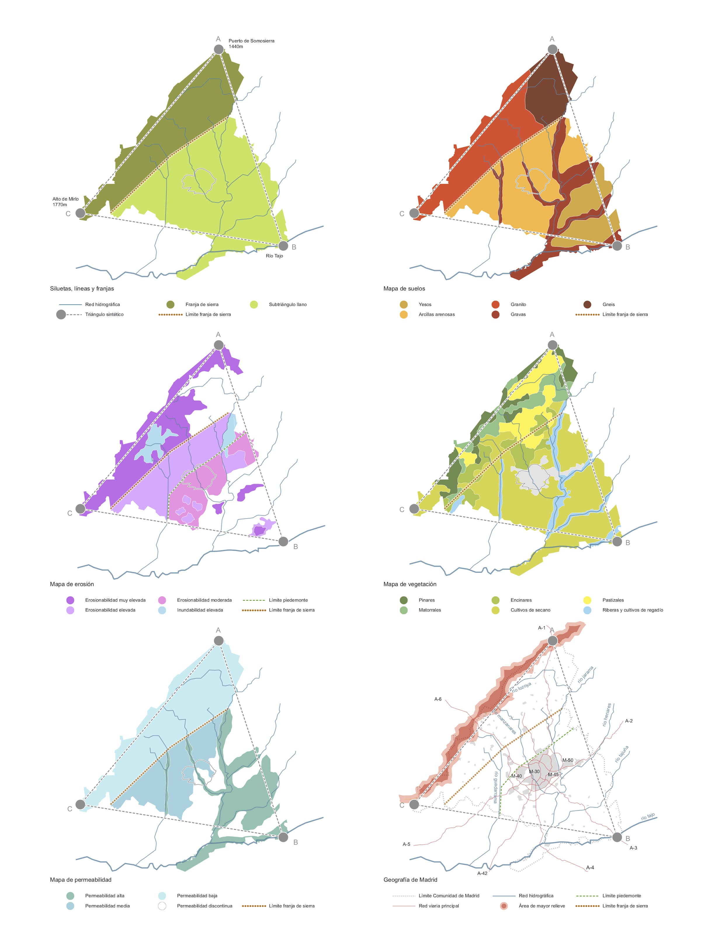
在建设过程的中途,2005年,市议会举行了一场公开的国际竞赛,以解决高速公路及其节点隧道施工留下的巨大公共开放空间。我们的团队认为这是一个巨大的地理干预项目,比高速公路掩埋留下的空地要大得多。从马德里北部塞拉斯的源头,到南部的高原和草地,想象、行走、绘制和理解整个河流是至关重要的,并需以某种方式将这种经验和地理现实融入到项目中。
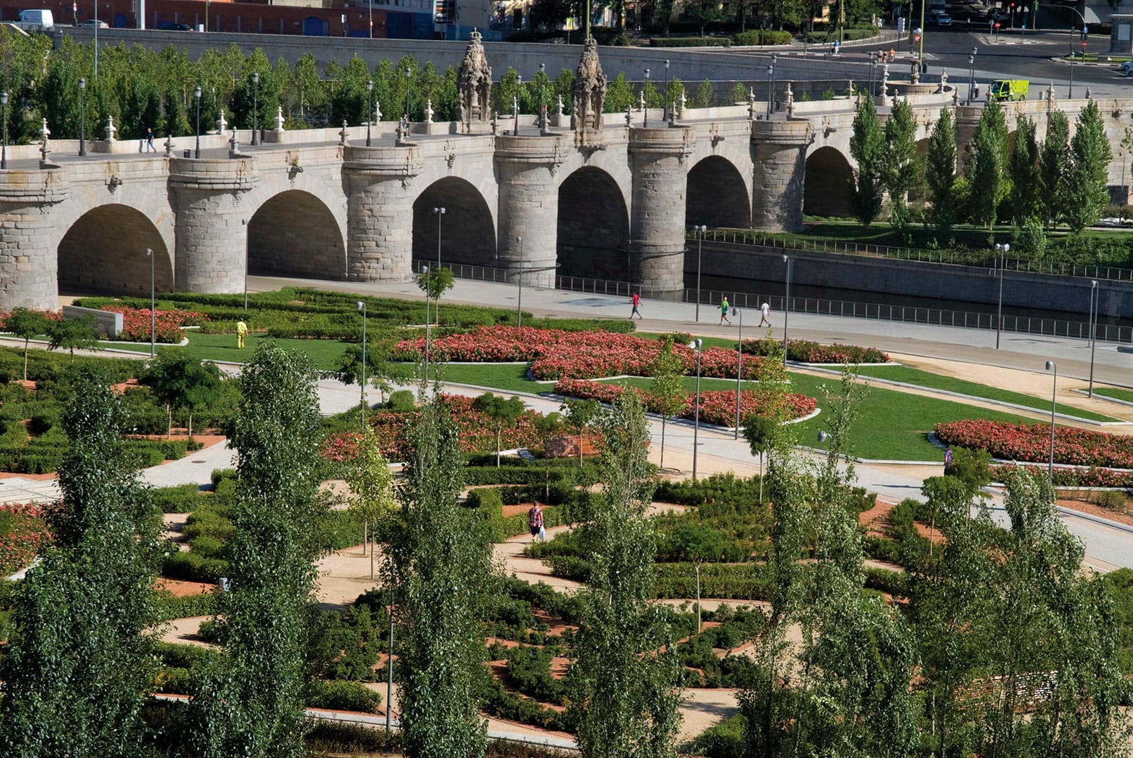
这个面积超150公顷的大型公园的设计包括高速公路掩埋后剩余的公共空间的重组和城市设计,其中涉及到:12座新的步行桥;6公顷的公共体育、社会、集体和艺术设施;城市海滩;儿童区;河流水利建筑遗产的修复。
In 2005, half way through the construction process, the City Council held an open international competition to solve the enormous public open space that the tunneling of the motorway and its nodes had left vacant. Our team regarded the project as a great geographical intervention, much bigger in scale than just the area left vacant by the burying of the motorway. It was essential to envision, understand, draw, and walk the river as a whole, from its source at the Sierras in the North of Madrid, to the plateaus and meadows in the South and somehow incorporate this experience and geographical reality into the project.
The design of this big park with a surface of over 150 ha consists of the reorganization and the urban design of the public space left available after the burial of the motorway and it includes: 12 new pedestrian-bridges; 6 hectares of public and sports facilities, social, communal and artistic amenities; An urban beach; Children’s areas; The restoration of the river’s hydraulic architectural heritage.

Madrid Río项目主要涉及两个主要城市目标:
1. 治愈40多年来城市和社会结构中的高速公路所造成的创伤,也治愈隧道工程本身造成的创伤,因为这些创伤也相当严重和具有侵略性。这些是通过设计和建造48公里以上的人行道;重组交通和公共交通线路和系统;在河上兴建12座新的人行天桥,并重新设计6座现有的人行桥使它们使用起来更加方便来实现的。
2. 设计和建造一个完全开放的公共空间,基本上全覆盖树木,可供所有人使用,溜冰者、自行车手、散步的人、登山者、跑步者、当地人和城市游客。纵向来看,它将马德里市令人惊叹的外部景观与强烈的城市色彩和极度密集的内部联系在一起,这些景观大多仍是原生的。这在像马德里这样紧凑而古老的城市是很难实现的事情。横向来看,它横贯历史城市中心与现代周边。因此,该项目在城市中心和周围宝贵的乡村之间建立了一种以前不存在的物理和概念上的连续性。因此,曼萨纳雷斯河成为了连接这座城市与其地理位置的节点。
Mainly, the Madrid Río project deals altogether with two urban targets that can be easily identified:
1. The project heals the wounds caused over 40 years by the motorway situated within the urban and social fabric. It also heals the wounds produced by the tunneling works themselves, as they were also quite significant and aggressive. This was achieved with the design and construction over 48 km of sidewalks; the reorganization of the traffic and the public transport lines and system; the construction of 12 new footbridges over the river and the redesign of 6 existing ones, making them more pedestrian friendly.
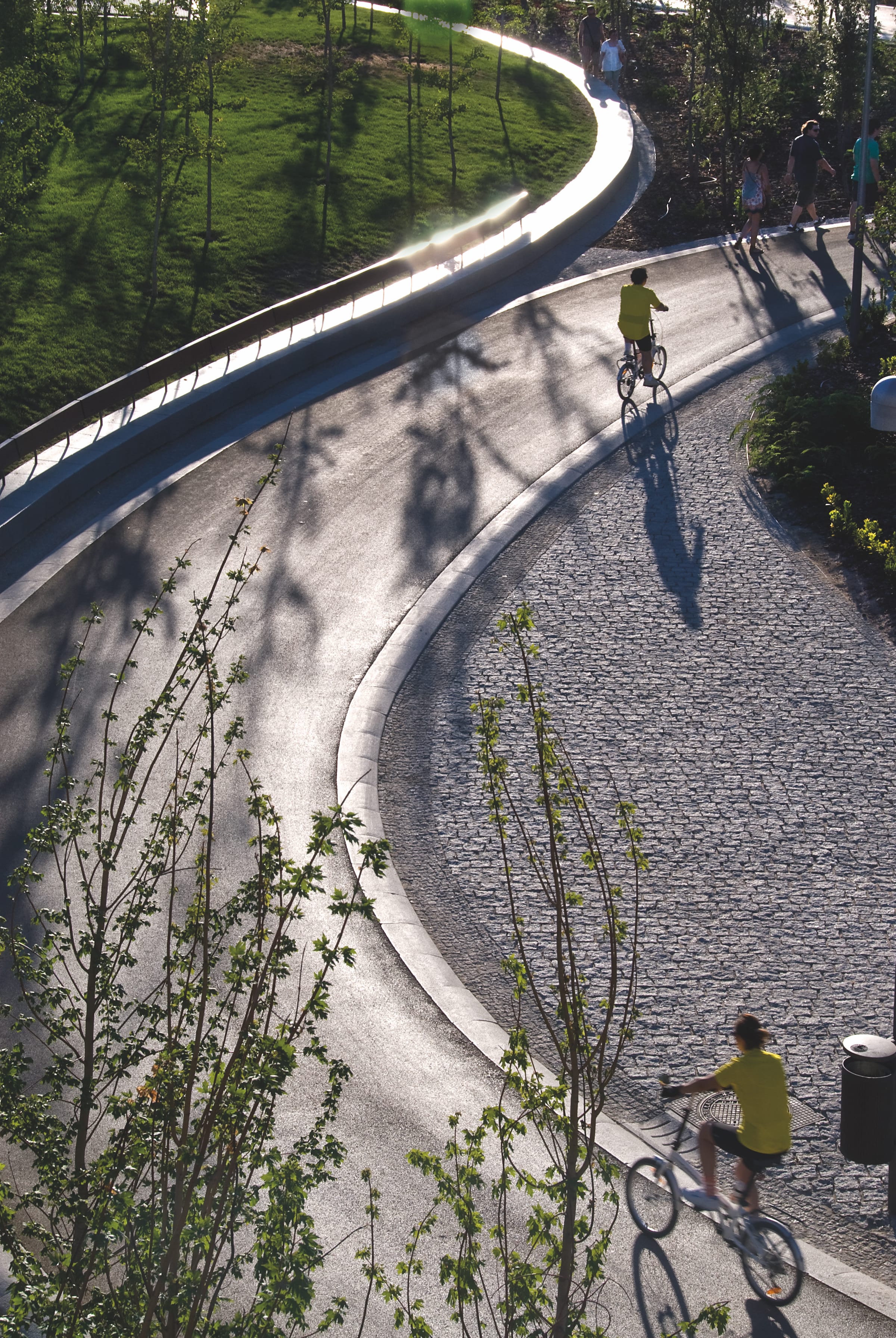
2. The design and construction of a completely open public space essentially covered with trees that can be used by all, skaters, cyclists, strollers, climbers, runners, locals and city visitors. Longitudinally, it links the amazing exterior landscapes of the city of Madrid, mostly wild still, with its strongly urban and extreme dense interior. Something difficult to achieve in compact and old cities like Madrid. Transversally, it connects the historical city center with the modern periphery. Thus, the project establishes a physical and conceptual continuity, which did not previously exist, between the city center and the valuable countryside that surrounds it. And as a result, the river Manzanares has become the node that connects the city with its geography.
该项目将基础设施和上层建筑联系起来;各种各样的的工程几何图形来自于这座城市;地下建筑与城市平面之间的陡峭地形,以及略微起伏的自然空间的虚构本质。地形以及地下结构的深度发生了很大变化,它的承载力在很大程度上决定了公共空间多变的地形。它还将隧道的紧急疏散路线及其紧急出口与地面散步通道的轮廓、排烟和脉冲系统、机械及其烟囱与马德里市的材料联系起来。
The project vertically links what is infrastructural to what is superstructural; the diverse and apparently chaotic engineering geometries to those geometrics belonging to the city; the abrupt topography of the buried constructions to the plane of the City and the fictional essence of a slightly undulating natural space. The topography and therefore, the depth of the underground structures, changes substantially. It is linked to its bearing capacity, which determines, to a great extent, the also variable topography of the public space. It also links the tunnels’ emergency evacuation routes and their emergency exits to the outline of the strolling pathways on the surface, the smoke extraction and impulsion systems and machinery and their chimneys to the materials of the city of Madrid; minerals to vegetation; cars to pedestrians.


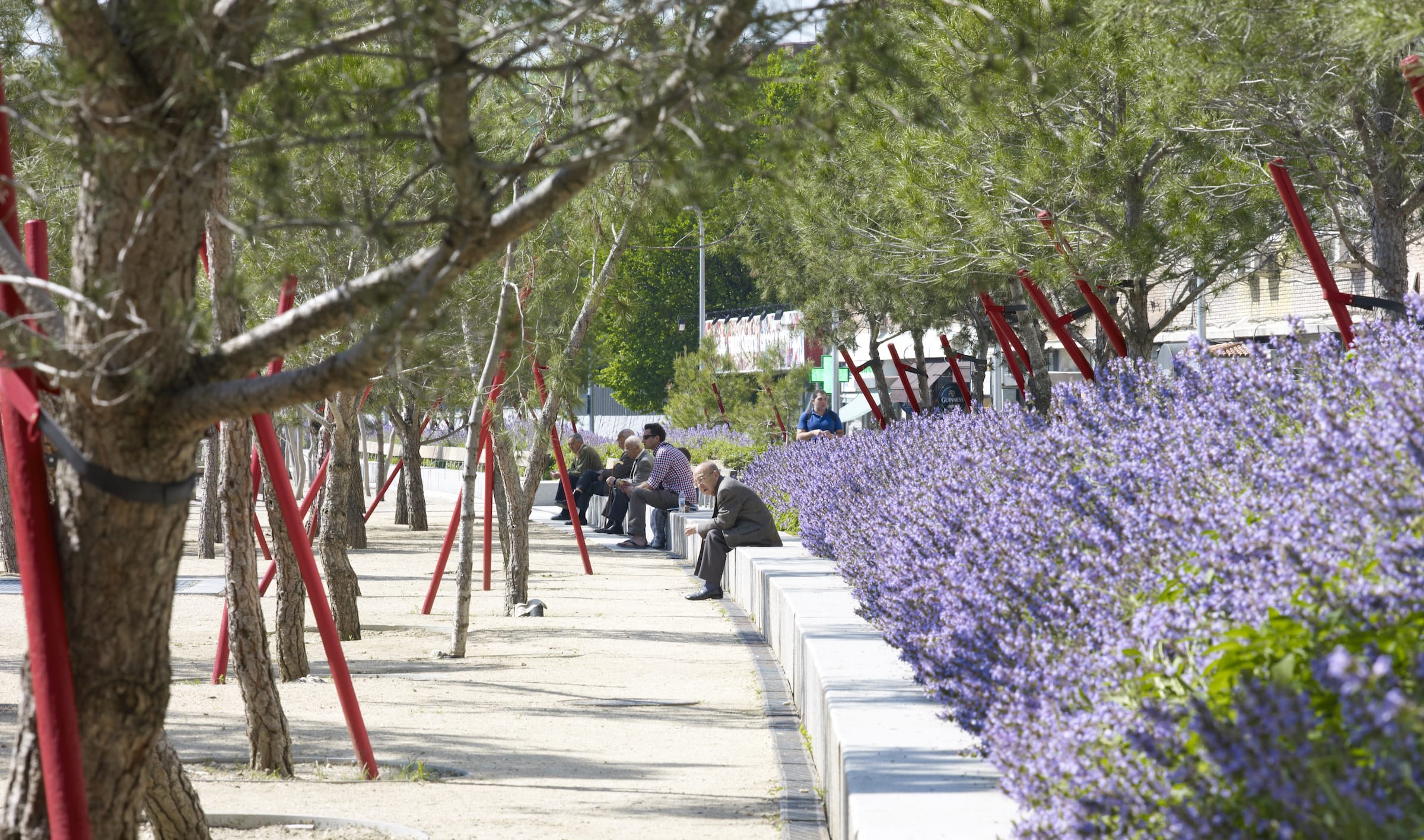
Madrid Río作为世界上最大的“城市体育场”之一,植被是它用来创造密集生态环境的主要材料,也是惰性地下基质上的生物景观。这可能是将大型基础设施和已建成的城市建筑与周围的自然环境最好地结合在一起的项目之一。该项目的目标是将景观、城市、建筑和城市基础设施结合起来,创造一个更加多样化的环境,一个更加绿色和宜居的城市。
Madrid Rio as a whole is one of the biggest “urban mat-building” in the world. Vegetation was the main material used on top of it to create a dense and ecological environment, a living landscape on an inert underground substrate. It is perhaps one of the projects that best integrates large infrastructures and the built urban fabric with the natural environment that surround them. The aim of the project was to make place where the landscape, the city, the architecture and the urban infrastructures combine to create a more diverse environment and a greener and more inhabitable city.


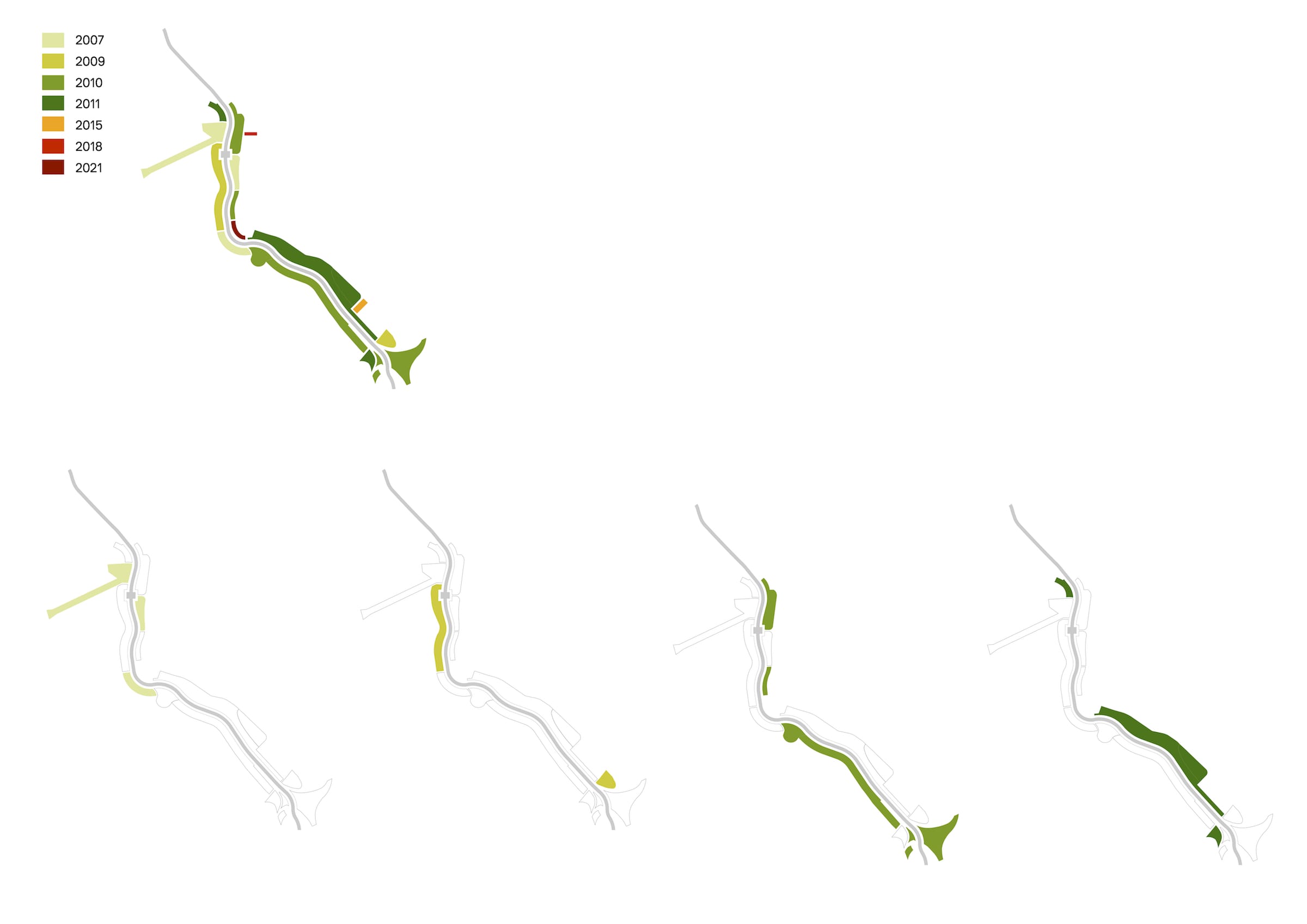
▼分区结构 Construction evolution
▼总平面图 General floor plan
▼分析图 Analysis
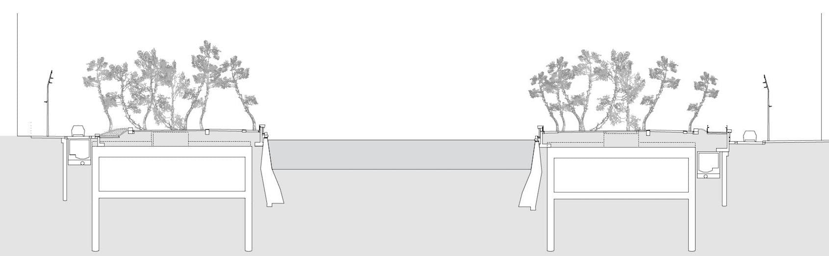
▼标准段剖面图 Standard section
项目名称:Madrid Río
项目地点:西班牙马德里
景观面积:15000.000平方米(150公顷)
设计年份及竣工年份:2005年(竞赛)、2005-2015年(施工)
客户:马德里市议会
建筑设计:
Burgos & Garrido:Francisco Burgos, Ginés Garrido
Porras La Casta:Fernando Porras-Isla, Arantxa La Casta
Rubio & Álvarez-Sala:Enrique Álvarez-Sala, Carlos Rubio
West 8:Adriaan Geuze, Edzo Bindels
建筑设计项目经理:Javier Malo de Molina
景观设计项目经理:Christian Dobrick
合作建筑师:Dominique Perrault
图片来源:Ana Muller, Jeroen Musch, Madrid City Council
Project name: Madrid Río
Project location: Madrid, Spain.
Landscape Area: 15.000.000 sqm (150 hectares)
Design Year & Completion Year: 2005 (Competition), 2005-2015 (Construction)
Clients: Madrid City Council
ARCHITECTS:
Burgos & Garrido: Francisco Burgos, Ginés Garrido
Porras La Casta: Fernando Porras-Isla, Arantxa La Casta
Rubio & Álvarez-Sala: Enrique Álvarez-Sala, Carlos Rubio
West 8: Adriaan Geuze, Edzo Bindels
Project Manager Architect: Javier Malo de Molina
Project Manager Landscape Architect: Christian Dobrick
Collaborating Architect: Dominique Perrault
Photo credits: Ana Muller, Jeroen Musch, Madrid City Council
更多 Read more about: Burgos & Garrido Arquitectos


0 Comments