

本文由 WEi景观设计事务所 授权mooool发表,欢迎转发,禁止以mooool编辑版本转载。
Thanks WEi STUDIO for authorizing the publication of the project on mooool, Text description provided by WEi STUDIO.
WEi景观设计事务所:如果一座城市的名字里藏着“海”字,人们自然会期待,在某个普通的周末,不必远行,便能与海风相逢。曾经的上海,海岸线更多是一道功能性的堤岸,守得住潮水,却留不住目光与脚步。如今,沿着 V 型海岸带展开的生态空间,一片片湿地、一段段滨海步道正在连缀成诗,让“去看海”变成这座城市最寻常、也最动人的日常。
“面向大海,我们做的不是一次简单的堤岸加固,而是一场城市功能的再生与人文情感的重逢——将海洋真正写进上海的城市基因。”
围绕国家“海洋强国”战略实施和上海韧性城市建设目标,聚焦上海滨江临海沿湾海岸带,2025年4月,上海市规划和自然资源局组织开展“上海‘V’型海岸带生态空间方案”国际征集工作,选出了清华院+WEi Studio + 上海市政院,MSP+上海现代院, Agence TER +ISA +浦东建筑设计院,中规院+TLS,天津华汇+AECOM共6家入围联合体。
最终,清华大学建筑设计研究院有限公司、WEi STUDIO、上海市政工程设计研究总院(集团)有限公司联合体在上海“V”型海岸带生态空间方案国际征集的两轮方案中获得第一名优胜。
WEi STUDIO: When a city’s name carries the character hai—the sea—people naturally hope that on an ordinary weekend they can meet the ocean breeze without going far. For many years, Shanghai’s shoreline functioned primarily as a defensive edge: it held back tides, yet did not invite lingering, views, or everyday access. Today, across the V-shaped coastal belt, wetlands, coastal paths, and public spaces are being reconnected into a continuous ecological poem—making “going to the sea” not an exceptional trip, but a gentle routine of urban life.
“What we are undertaking is not a simple reinforcement of seawalls, but a regeneration of urban functions and a renewed emotional bond with the sea—embedding the ocean into Shanghai’s urban gene.”
Background and Competition
In alignment with China’s Maritime Power strategy and Shanghai’s goals for resilient-city development, and focusing on the riverfront–seafront–bayfront coastal corridor, the Shanghai Municipal Bureau of Planning and Natural Resources launched the International Solicitation for the ‘Shanghai V-Shaped Coastal Belt Ecological Space Plan’ in April 2025. Six consortiums were shortlisted. Ultimately, the consortium formed by Tsinghua University Architectural Design & Research Institute (THAD), WEi STUDIO, and Shanghai Municipal Engineering Design Institute (Group) ranked first after two rounds and was awarded the winning scheme.
▽项目视频
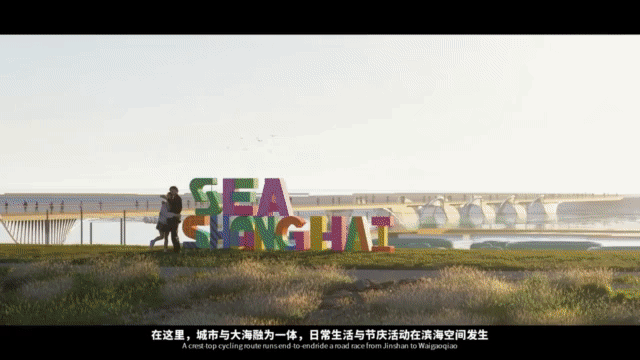
设计愿景 SEA 上海(SEE SHANGHAI),是在浪花与天际之间,重新勾勒这座城市的轮廓,提出一份“中国式海洋文明的上海方案”:看得见海、走得近海、融得进海,让城市与海岸彼此成就。
分段铺展的上海色彩画卷
如果把上海看成一首色彩诗,V 型展开的海岸带,像一幅被缓缓拉开的长卷,从冷冽到温暖,从理性到诗意,一段段写下上海面向大海的新注脚。
Vision: SEA Shanghai (SEE SHANGHAI)
SEA Shanghai (SEE SHANGHAI) proposes a Shanghai answer to a “Chinese approach to maritime civilization”: to see the sea, get closer to the sea, and live with the sea—so that city and coastline can shape and elevate one another.
A Coastal Scroll of Shanghai in Color
Unfolding in a V-shape, the coastal belt reads like a long scroll—from cool to warm, from industrial rationality to coastal lyricism.
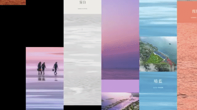
由于淤积与侵蚀,上海滩形成北段硬核、中段生长、南段柔软的三种气质。这三组色彩,共同构成上海的海岸带“北翼创新港”、“中段门户岸”、“南翼风情湾”不同色调。
Due to patterns of sedimentation and erosion, Shanghai’s shoreline reveals three distinct “characters”: a hard northern reach, a growing central reach, and a soft southern reach—corresponding to three coastal tones: Northern Wing Innovation Harbor, Central Gateway Shore, and Southern Wing Scenic Bay.


北段,是偏“硬核”的冷色调:
沿着海岸线排开的是邮轮港、集装箱港、外高桥船厂、三岔港与东方枢纽——巨轮靠离,桥梁跨海,码头灯火彻夜不灭。钢铁的深蓝与港口的暖橙在海天之间此起彼伏,汇成一幅力量感十足的海洋产业画卷,让人一眼就看见这座城市面向大海的底色与魄力。
吴淞口邮轮港,巨轮贴岸,世界在此远航。
Northern Reach: the “hard-core” cool palette
A coastline of cruise and container ports, shipyards, major estuaries, and strategic gateways—where steel-blue infrastructure meets the amber glow of port operations. This former mono-functional “production front” is envisioned to evolve into a seaward urban foyer, offering new public access while sustaining industrial vitality.
Wusongkou Cruise Port: positioning as an ocean-facing civic reception space and professional visitation hub.

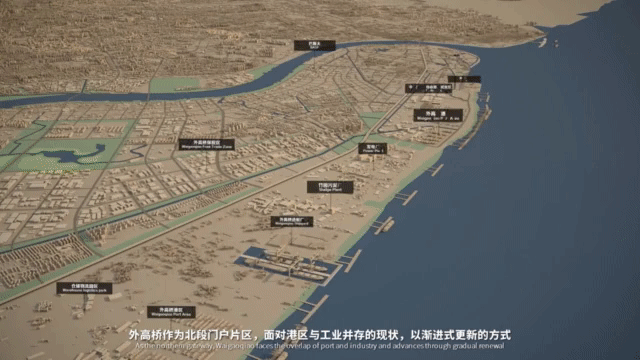
面对港区与工业并存的格局,这片曾经单一的“生产前沿”,正通过渐进式更新,悄然转身为“城市面向大海的前厅”。这里将打造海洋城市会客厅——上海首个滨海专业型访问港枢纽,让更多人与大海、与世界,在此相遇。
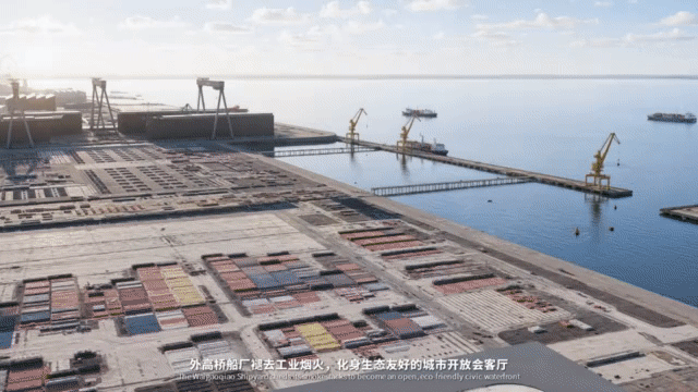
外高桥码头获得新生,铺展成市民可达、可行、可停留的滨海滩涂与亲水空间。登临栈桥远眺,在浪声与汽笛间,人们能够切身感受“世界第一大港”背后积淀的文明与自豪。
Waigaoqiao waterfront: transformation toward accessible coastal flats and people-oriented shore spaces.
川杨河口则化身为盐沼湿地,成为长江口国家公园的科普前沿,为城市保留一片可以观察潮起潮落、鸟栖鱼跃的原生态课堂。
Chuanyang River estuary: restoration into saltmarsh wetlands, serving as a science-education forefront for the Yangtze River Estuary National Park.


中段,是“生长中的暖色带”:
以南汇新城为核心,从河口滩涂一路延展到东海大桥落地点,东方日出的朝霞红,与风机的律动、光伏的闪耀和碧海的深邃交织成一抹“未来的科技银”。
这里既是上海走向大海的展示窗,也是新型社区、海洋教育以及创新实验不断萌芽的试验场。
Central Reach: a warm belt in growth
Centered on Nanhui New City, extending from estuarine flats toward the Donghai Bridge landing, this section merges sunrise reds with the rhythms of wind power, the shimmer of photovoltaics, and the depth of the East China Sea—forming a “future-tech silver.” It is both Shanghai’s ocean-facing showcase and an experimental ground for new communities, marine education, and innovation prototypes.


南段,则是一条“柔软的疗愈色谱”:
奉贤的浅滩与金沙海岸、海湾的森林与鸟类湿地、金山的落日与海上运动,从淡蓝到金橙,再到碱蓬红、暮色紫,一路向杭州湾缓缓铺陈。这里强调的是“美疗海湾”与“文旅慢生活”:
在一小时通勤圈内,都市人就能走到真正自然的海边,踩在细软的沙上,看潮水起落,在海风里放慢心跳,找回属于上海的海岸温度
Southern Reach: a soft, restorative spectrum
From Fengxian’s shoals and sandy beaches, through bay forests and bird wetlands, to Jinshan’s sunsets and sea sports, the palette flows toward Hangzhou Bay—pale blues, golden oranges, seepweed reds, and dusk purples. Here the focus is on a healing bay landscape and slow coastal living—where, within a one-hour commuting radius, residents can reach a truly natural shore, feel tides and wind, and reclaim Shanghai’s coastal warmth.


陆海统筹下的海岸带
从黄浦江、苏州河走向整条海岸,我们讨论的,不是“再造一座滨海新城”,也不是只盯着一条防汛堤线,而是把这条 V 型海岸带视作一个完整的陆海统筹大地系统:既要守得住安全,又要留得下风景,更要装得下生活与产业。
The Coastal Belt as an Integrated Land–Sea System
This proposal does not aim to “build another coastal new town,” nor to treat the shore merely as a flood-control line. Instead, it frames the V-shaped belt as a land–sea integrated territorial system—one that must secure safety, preserve landscape value, and accommodate life and industry.
以三大战略重塑V型海岸带

“海塘生境链”
在夯实防洪安全的前提下,修复潮滩、盐沼和海岸林,将传统海塘升级为承载多元生境的蓝色生命线。
尊重海潮、风暴潮与泥沙运动的规律,把漫长海岸拆解为一段段可迭代的“适应单元”:
每一段,都不是简单“做景观”,而是寻找最合适的自然方案——让自然多做一点,人为少做一点,让堤岸既挡得住潮水,也留得下生机。
Three Strategic Frameworks
1) The “Seawall Habitat Chain”
On the basis of strengthened flood defense, the scheme restores mudflats, saltmarshes, and coastal forests, upgrading conventional seawalls into a blue ecological lifeline. Respecting tides, storm surges, and sediment dynamics, the coastline is reorganized into iterative adaptive units—prioritizing nature-based solutions wherever possible: let nature do more, and construction do less.

“超融共生带”
统筹生产、生活、生态空间,打破岸线“元素混杂”的无序状态,转向功能清晰、秩序分明的多元岸带。纵向上,从北到南形成清晰序列:三大海岸带范式,带动三大段落,勾勒出风格各异的魅力岸线。
The “Ultra-Integrated Symbiosis Belt”
The plan coordinates production–living–ecology to replace the previous shoreline’s mixed and disordered pattern with a clearer, more legible coastal structure.
Along the coast (north–south): three coastal paradigms anchor three distinct segments and identities.

横向上,贯通内外岸线,重构水陆关系,形成多层联动的“五道空间系统”,让自然、城市与日常生活能在同一条海岸带上真正“共生”。
Across the coast (land–sea): a linked “five-layer spatial system” rebuilds the relationship between water and land, enabling true coexistence of nature, city, and everyday life.

“奇点未来极”
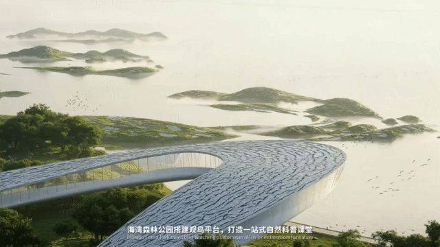
沿着海岸布局一批具有强带动效应的关键节点,以高品质公共空间叠加科创、文化、文旅等复合功能,把零散岸线转化为引领未来的“活力极点”。他们将成为 V 型海岸带的前沿引擎,向外持续释放动能,带动整条生态海岸带的系统性更新与生长。
“Singularity Future Poles”
A set of catalytic coastal nodes is introduced—where high-quality public realms are coupled with innovation, culture, tourism, and hybrid programs. These “vitality poles” convert fragmented edges into a system of forward-looking engines, radiating momentum and driving continuous renewal along the entire belt.

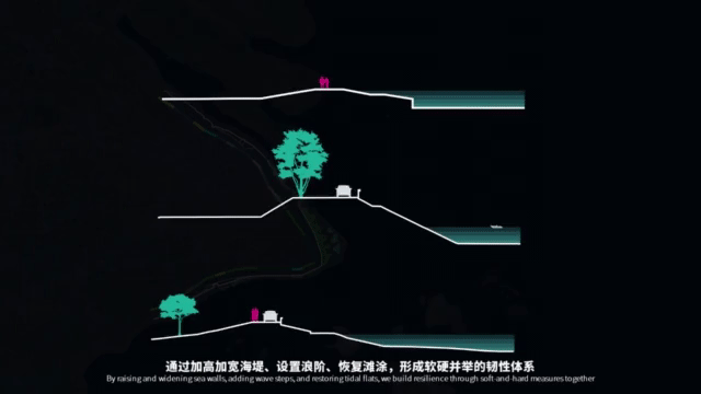
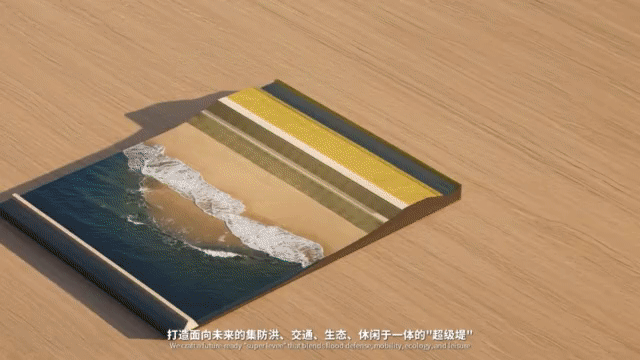
从防汛墙到“超级生态堤”
到 2050 年,上海沿海将面对更高的水位和更频繁的极端天气。
仅仅把堤坝“再加高一米”,不仅成本高昂,也会让城市一步步退向内陆,与大海渐行渐远。海岸带在不同岸段将采用单堤或双堤并行的方式,塑造多层次生态岸线,打造面向未来的“超级堤”——在防洪、交通、生态、休闲之间找到新的平衡。
通过加高加宽海堤、设置浪阶、恢复滩涂,形成软硬并举的韧性系统。
From Flood Wall to “Super Ecological Dike”
By 2050, Shanghai’s coast is expected to face higher sea levels and more frequent extreme events. Simply raising dikes is costly and risks pushing the city progressively inland. The proposal advocates single- or double-dike systems by segment, shaping multi-layered ecological shorelines and a future-ready “super dike” that balances flood protection, mobility, ecology, and public life.
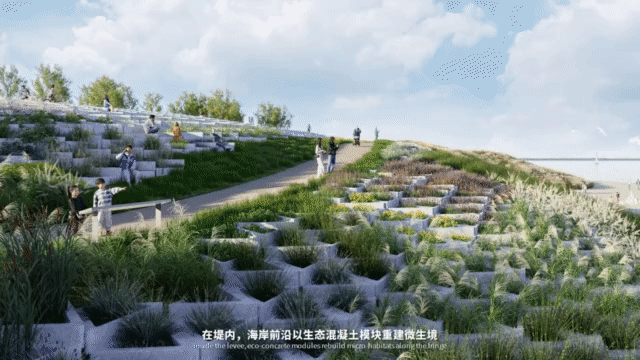
在海岸前沿,以生态混凝土模块重建微生境,以生态固堤构筑自然缓冲带。
亲海沙滩与功能道相连,织就步行、骑行、车行一体的陆海交通体系,拓展水上活动的界面,提升滨海的通达性与利用效率。“超级堤”,不再是冷冰冰的一堵墙,而是一条可行、可憩、可亲近的海岸长廊。
Key approaches include widening and raising dikes, introducing wave steps, restoring tidal flats, and building a hybrid resilient system that combines engineered and ecological measures. At the frontline, eco-concrete modules and bio-stabilization rebuild microhabitats and natural buffers. Connected beaches and multi-modal corridors weave walking, cycling, and vehicular routes into an integrated land–sea network, expanding interfaces for water activities and enhancing coastal accessibility and use.
The “super dike” is no longer a cold barrier, but a living coastal promenade—walkable, restable, and intimately connected to the sea.


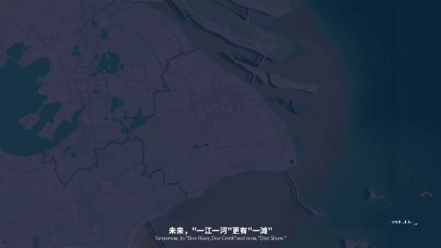
顺着上海伸向大海的那一笔,将来会铺展开一条独特的“V 型海岸”。它以一条“海岸生态缎带”贯通全市海岸线:在冷冽的产业蓝里刻下港口的节奏,在暖橙的海湾里安放散步与小憩,在湿地的深红与暮色的紫里留给候鸟与潮汐一片宁静。
防护藏在脚下,生态展现在眼前,开放写在岸线上——从那时起,“看海”不再需要一次郑重其事的远行,而是上海每日翻开的生活诗篇。
Toward a Daily Shoreline Poem
Along the stroke by which Shanghai reaches the ocean, a distinctive V-shaped coast will unfold—stitched together by an ecological coastal ribbon. In cool industrial blues, the rhythm of ports remains; in warm bay oranges, strolling and pause are restored; in deep wetland reds and twilight purples, quiet territories are reserved for birds and tides.
Protection is built beneath the feet, ecology is opened to the eye, and openness is written into the shoreline—so that “seeing the sea” becomes not a ceremonial journey, but a daily page in Shanghai’s living poem.
项目名称: 上海“V”型海岸带生态空间规划设计
完成年份: 2025年
项目面积: 全线海岸线总长度218,2公里,其中陆域空间约769.4平方公里,河口海域空间约412.7平方公里。
项目地点: 上海“V”型海岸带
设计公司: WEi Studio;清华大学建筑设计研究院有限公司;上海市政工程设计研究总院(集团)有限公司
公司网址: http://www.weistudio.net/;https://www.thad.com.cn/;https://www.smedi.com/
联系邮箱: jiya@weistudio.net
设计团队:
WEi Studio:陈巍,常骥亚,蔡昊家,刘芳菲,吴华,王颢璇,梁铠泓,陈庭威
清华大学建筑设计研究院有限公司:沈璐、戚毅君、孙琮、傅云潇、张荩引、林思琪、杨颖
上海市政工程设计研究总院(集团)有限公司:景观专业:贺文雨、陈榕;交通专业:王建蓉、袁野、阚黎明;水利专业:刘鹏晨、侯捷
特别感谢:王靓
客户:上海市规划和自然资源局
“ 一条贯通全市海岸线的“海岸生态缎带”。”
审稿编辑:Maggie
更多 Read more about: WEi景观设计事务所


0 Comments